Sunday, May 12, 2019

GoSmokies in Cosby

Originally Posted on GoSmokies November 11, 2013

This was our 4th GoSmokies event and since we have our latest adventure coming up this Sunday, I want to finish posting all the blogs from the past events. This will be the first one that we have had since two years ago. We stopped because their appeared to be a lack of interest in continuing the tradition. Thus, the turnout this Sunday could determine the future of this event. We have done 10 and I have only missed one of them (#9.) I can truly say that I have enjoyed them all and look forward to seeing folks this Sunday. Anyway, without further ado, here is the blog from GoSmokies #4. For whatever reason, I did an album of pictures rather than embodying them in the blog. Thus, they are at the end.


GoSmokies in Cosby

As I stood in the Cosby hiker parking lot with 21 fellow GoSmokies members, I had a plan. I had the map which I posted in an earlier blog, a map from Ella Costner’s book, a couple of her famous poems, and some notes for the hike. I read Costner’s “Ode to the Smokies” with its blessing and warm overtones of the beautiful mountains she so enjoyed in her youth. I stated that this hike was different from previous GoSmokies hikes in the sense that there were some unknowns. Most of the home sites on the first park of the hike were ones I had not previously visited and we would therefore be exploring together. I said that this was a big area and with so many folks we should find items many have missed before. Mike Maples with his vast knowledge of the area lead the way to some cars and places that he had previously been to. In the end we would not make it to the end of Crying creek. Why? Because we found so much that we ran out of time to go any farther. As we walked out to Cosby park road, even the Jedi looked over at me and said that we had found things he had not seen before. And the contributors were many. Jedi points were awarded and smiles grew large as we found chimney remains and old cars including the large frame of an old Buick touring sedan.


We started up Gabes Mountain trail with one stop for a home site along Rock Creek. The “ON” trail experience ended at Messer Gap as we stopped at the “Jennifer” grave before starting down the old road to Crying Creek. We would find no large chimneys today as we stopped at a couple home sites in Bearneck Cove. But, the numerous car remains would more than make up for the lack of tall chimneys as we soon came to the Buick remains.
It was such a great day with old and new friends off the beaten path. We found more home places and cars as we continued our most wonderful adventure. I think that I will just let the pictures tell the story so be sure to click the link below.
Considering the postponement of the original October hike, the turn out was very good. Hopefully we can do another one this winter. This is a great bunch of people who are always out hiking the mountains. If you have never been off trail then these are golden opportunities to gain experience and learn from some very knowledable people. In fact, a great percentage of the people on this hike carry a lot of knowledge in their torch. Dave Ledbetter is a really great guy and has the privilege of a Father who has an enormous amount of knowledge about the Smokies. Aside from all that knowledge he is a really great guy too and I love every minute that I get to hike with the Ledbetter clan. I wouldn’t want to tangle with Marlene Denton in a dark alley, but she is the kind of lady who would give you the shirt off her back if you were in trouble. At the very least, she would give you G.W.’s (her husband) shirt LOL. So, the next time you hear about a GoSmokies hike consider it an opportunity to hike, laugh and learn from a group of great people. And some very fine people responsible for organizing the event could not be present this time. A big thank you to Eleanor, Frank and Bonnie for all the behind the scenes work on these event. We love you and missed you, but know you’ll be with us next time.


Friday, March 29, 2019

The Falls of Rhododendron Creek


Been up Rhododendron creek a few times over the years; however, today’s hike had a little more meaning. It had been a few years since I traversed the creek once known as Big Laurel. I first heard the original name from my good friend Mike Maples. I never got to hike the trail with Mike, but I came to know that one of his favorite waterfalls was located along it pathways. Mike’s falls is one of many found along a mile and a half stretch of Rhododendron Creek. Tennessee Landforms shows one waypoint and simply calls it Rhododendron Creek Falls and indicates 13 cataracts comprising the stretch of falls and cascades. After our hike, I did a little research and found that Greg Plumbs second edition of his Tennessee Waterfall book listed 8 named falls. Depending on criteria, some of the waterfalls and cascades along the creek merely qualify as pretty photo ops as opposed to official waterfalls. A few of the waterfalls apparently have local names so for the purposes of this writing, I will list both the local name and names given by Greg Plumb in his book. Today was also a great opportunity to locate three home places that I had missed on earlier hikes and named from maps by Glenn Cardwell. With side trips, our hike today was 4 miles round trip. I was joined by Marlene Denton, Duane Pierce, Jim Rigsby, Denise Cameron, Charlie and Denise Denney.   


The trail is not difficult to follow, but there is one stream crossing near the beginning of the hike.


I was not sure that the first falls really qualified; however, Greg Plumb has this one listed as Oldhamii Falls in his book.


The next falls is locally called Triple Falls, and is listed as Rhodora Falls by Greg Plumb.


We attempted some group photos at this lovely falls, but the only one that turned out was of this very silly man!


The next falls is locally called Sideways Falls and listed as Pinxter Falls by Greg Plumb. I had to look up some of the interesting names given these falls by Mr. Plumb and found many of them to be various azalea names. A Pinxter, or Pinkster is commonly known as a Pink Azalea.


The next two have limited views from the trail and are a bushwhack down to the creek to get a better view. I believe that I did that on previous hikes, but settled for the trail view today. The first one Plumb calls Mountain Laurel Falls.


The second one Plumb refers to as Glenn Dale Falls. No idea why he named it this.


Next one found in Plumb’s book is Azalea Falls


Followed by Kurume Falls. A Kurume Azalea is a hybrid pink to crimson azalea. This waterfall was further given the name Stair Step Falls by Marlene.


Alas we come to the Jedi’s Favorite that we will forever know as Mike’s Falls.


Mike's Falls is listed in Greg Plumb’s book as Alpenrose Falls. Alpenrose or Rhododendron ferrugineum is an evergreen shrub that grows just above the tree line in the Alps, Pyrenees, Jura and northern Apennines, on acid soils.
It was here that the silly man was finally able to get a decent group photo! After a few comical attempts at setting a timer and reaching the group, the silly man settled for a squat off to the side!


Here we see Jim and Marlene amidst the Rhododendron that likely gives this creek its name.


As previously stated, there are many small waterfalls and cascades found along the creek so your number may vary depending on what you think qualifies as a waterfall.


The last home place before reaching Grapeyard Ridge belonged to George Rayfield   according to Mike Maples. I can hear Maples now telling family history and me asking him whose chimney this was. I had hiked to the upper reaches from Ted’s Branch years ago with MM and good buddy Ben Bacot. Lots of great memories from those hikes!


Great friends, great hike, but still one more home place to find on the return trip. Hey Marlene, which way do we go?


I had looked for the home place on the way up but decided against another stream crossing early in the hike. With warmer temperatures and being near to the car, I decided that getting wet was a worthwhile risk. The rest of the group decided to let Crazy Gourley scout ahead in the event there was nothing to find. It tuned out to be a little farther up the creek than what my plotted GPS waypoint had shown; however, I did find what little remained of the chimney along with some foundation rocks. According to a Glenn Cardwell map, it belonged to Richard Whaley.


Finding this home place was a nice way to end a great day along Rhododendron Creek. Despite not being an official park trail, this little gem is no secret and is traversed by numerous hikers each year. In fact, I think the trail is better than some of the official park trails.

Tuesday, March 5, 2019

GoSmokies Fall 2012

Originally Posted on GoSmokies November 16, 2012

I have already posted a little history and some photos from our second day of the GoSmokies hikes. I think the consensus is that a good time was had by all. We visited so many home sites and saw a lot of cool stuff that a book could be written and maybe even a blockbuster movie made!


As was expected we got a big history lesson from Mike Maples and if you were wise enough to listen you got some interesting tidbits from the senior Dave Ledbetter. I sincerely hope we take advantage of his knowledge and invite him to take us on a hike in Whiteoak Sinks or Cades Cove in the future. We could bill it as GoSmokies III: A Hike with the Dave’s! I have learned a lot from both father and son and I thank them for sharing their knowledge with me.


Now for my map people out there we begin with a section of the famous Maples Greenbrier hand drawn limited edition map. Mine is about a year and a half old and already outdated lol! We discussed some revisions on Wednesday which you will soon see on my GPS map.


Even Mike would agree with me that everything about the Smokies is subject to revision. If you think trying to figure out who lived where in the Smokies is easy – think again. I am constantly revising due to new information. To make it even harder you will find that folks moved around a lot. Folks even swapped places back then.
Now if you would like your own full blown, hand drawn, revised and ever changing edition of the map then simply ask Mr. Maples very nicely and he might just draw you one. Only $300…. Just kidding (it depends on just how nicely you ask lol!)
Now we hiked so durn far that the home sites are kind of cramped on my map of the entire hike so on the right you will see a larger version of the upper part of the hike.


Since my map is computer generated it is only worth about 30 cents. But go ahead and right click it and just steal it! Now after I die it will be worth a lot more and if you visit my grave I will be happy to autograph it for you at no extra cost!
And lastly I give you the ever popular 1931 map which in the corner you see my attempt at layering it onto a topo map. I tried this based on a blog written a little while back and it is a great idea; however, it took me so long to do it that I lost interest in ever attempting it again. For those of you who have the patience and skill I say go for it.


And lastly, if you have not got your fill of pictures (as if 27 8x10 color glossy photographs isn’t enough) you can click on the link below and I have a You Tube video that should satisfy your appetite.


Thursday, March 22, 2018

Hiking Copeland with the Boss


Between weather, finishing a book and working lots of hours at my job, getting out in the woods has been a difficult task these last few months. Since I typically work weekends, I have not seen many of my hiking friends for several months. In fact, it was reaching such severity that I received and urgent message from the BOSS! Not to be confused with my work boss; this boss is the real BOSS, the head honcho, the Big Cheese! I reverently speak of Marlene Denton who is without a doubt the BOSS! “How did she become the BOSS?” you ask. I suppose there are several reasons; however, the main reason being that Marlene is the only human on the face of planet earth that can tame the wild and wily energizer bunny many of us know as Mike Maples! Many have tried to contain that spirited bundle of energy that inhibits the body and soul of Mike Maples. Ben Bacot tried and failed. Maples sent him to live in an old abandoned brewery in South Carolina. Richard Owen sent an army of Puffins to capture the Mountain Jedi; but they too were defeated and are now floating adrift on an iceberg in Antarctica. Many others have tried, but all have failed except Marlene. Thus, when I got the message from Marlene that she was taking a day off work and that my presence was required; I replied most hurriedly with an affirmative “YES BOSS.” We set the date and had planned to meet in Greenbrier for some off trail adventures. The original forecast looked optimistic. But the day before all that changed. Morning showers with an afternoon break, followed by an evening forecast of gloom and doom. I awoke the aforementioned morning to clear skies. I grabbed my phone to see if the weather folks had called off Armageddon. I was assured that the rain was coming; however, the afternoon would be free of the wet stuff. I quickly messaged the BOSS and suggested that we delay our hike, meet for lunch and then decide where to hike at that time. Marlene agreed, suggested a lunch meeting place and Plan B was made. I crawled back under the blankets and grabbed another hour of slumber only to awaken to white fluffy clouds and heavenly blue skies as I walked outside! I made ready and headed out to meet the BOSS at Trish’s Mountain Diner outside of Gatlinburg. I thought that perhaps the rain had somehow missed me and that I would drive into it enroute to G’burg. Alcoa was blue skies. Wears Valley was blue skies. Pigeon Forge was blue skies! Nowhere along my route did I encounter rain or any dark clouds! Was the rain late? I checked with the weather gods. Once again, they assured me that it was supposed to be raining and that the afternoon would be dry! Dazed and confused, I proceeded to the designated lunch place. Marlene and her husband George were awaiting me with table procured. They had brought along a girl they only identified as Dorothy to whom the BOSS said was looking for her lost dog. I believe the dogs name was Toto or something like that.
After lunch, we decided that in the interest of having more time to hike that we would drive to nearby Copeland Creek and do some exploration in this area that was once a well establish community prior to the establishment of the Park. The 1931 shows the old roads going up Copeland Creek. There were roads up Big Copeland, Middle or Little Copeland, and the Left Fork.


This map only shows the families living in Copeland at the time of the map and that Maples guy has done a lot of research on families that lived in this area throughout different time periods. Both of us have written several blogs from hikes in Copeland and I believe that Maples covers it in one of his books. My book does not cover Copeland; however, I think that Maples is mentioned once or twice!
Some of Glenn Cardwell’s family called Copeland home and it was from his maps that I discovered some home places that I had missed on prior visits. In fact, there are several hand drawn maps of families that called Copeland home; thus, naming places can be a debatable chore depending on your source. And just like other areas of the Smokies, people moved around and sometimes did a little house swapping. But enough of this banter; the BOSS wants to get hiking!


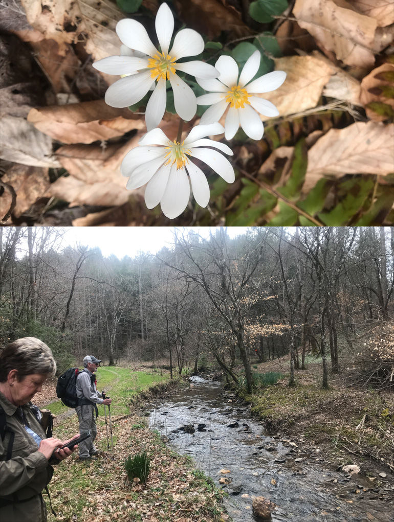
Despite the forecast for winters return, spring wildflowers were making their first appearances along the forest floor.


The main road heads up the left fork of Copeland; but we wanted to stay with Big Copeland and head for some unfound home places. Look for the subtle remains of a home place to your left after crossing the creek. There is little left of the chimney; however, George found some detritus a short distance from the chimney pile. Detritus is a fancy word for miscellaneous remnants that I stole from my good friend Mike Knies. Furthermore, you might call it a fancy word for garbage!


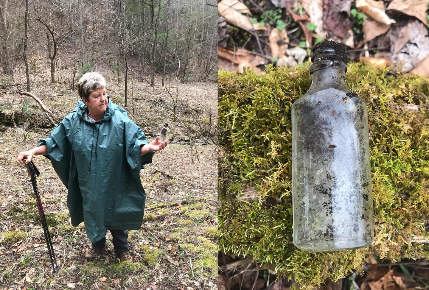
We made several easy crossings of the creek today and I soon learned that the young lady who accompanied us was not really Dorothy. Nor was she looking for Toto. The mystery guest was in fact Jamie who was not in search of her dog; rather, her quest was the retrieval of her picinic basket which had been stolen by some bear named Yogi. Considering that George had an evil grin on his face during the dissemination of this information, I found the whole story rather implausible.  


 After crossing the creek we came to another home place (1226 on the map below) with a tub hanging from a tree limb.


George dashed back across the creek to investigate the remains of an old kettle. Although he would have you believe that it was a helmet from an alien being that travelled to the Smokies from the Andromeda system!


Up the creek, I was hoping to find remains of the Bonwell Chapel which was on Glenn Cardwells map and the 1931 map. My apologies to the BOSS, as I misspelled it on my GPS and was calling it the Bonewell Chapel! Most churches did not have a chimney; thus, locating any remains can often be a daunting task. However, from the main road there is short road that abruptly ends next to a side creek.


Above it is a flat area where upon close examination appeared to be where the Chapel once stood. Furthermore, we noticed some rocks that were likely part of the Chapels foundation.


Continuing the creek we came to our next home place which I accidentally left off my map above. It was in between the Chapel and home place 1227 on the map.
Lots of  detritus and more signs of spring located near the chimney remains.


A driveway heads uphill to the chimney remains.


The road ahead turned ugly which meant another creek crossing. Creek crossings are the BOSS’s favorite part of the hike as she informed me on her way across.


George decided to brave the “ugly” and came out at what Mike Maples calls Camp Rock.


I believe that Maples makes some sort of historical reference as to the name of this overhang; however, I have it from a very reliable source that Maples (in his younger years) was in the company of some young ladies and got a little inebriated. Unable to stagger back to his car, he passed out under the rock and awoke with a horrendous headache! Marlene found evidence of his shenanigans a little farther down the creek.


Even more evidence was found a short distance later!


But let us not be too harsh on the Mountain Jedi. After all weren’t we all young and foolish at one point in our lives?
Just past Camp Rock is a large clearing and another home place.


According to one of the maps this home belonged to Margaret Parton and from Glenn Cardwell’s map there were supposed to be two more Parton family places up the hollow. Neither of these home places or the creek that runs up the hollow is found on the 1931 map.


The area where the first home place was supposed to be located did not appear very plausible as only a very small flat surface was visible. In fact, the creek narrowed and it appeared that the trail dropped into the creek and continued along the other side. A fallen tree required a quick crawl underneath to come out ahead to the remains of the home place of what the map said belonged to Mike and Linnie Parton.


A chimney pile with a root cellar below it were all that remains today along with one piece of what was once the family stove.


I was pleased to have found at least one of the home places that I sought. Soon I rejoined the group as we headed back down Copeland Creek for a group picture at Camp Rock.


On the way back we decided to head up to the Rector Cemetery along the Left Fork of Copeland. Looking at my GPS, there was one more home place that I had marked from the Cardwell map. A narrow and ugly passage awaited me to reach this home place. The BOSS decided to let me investigate this one on my own. It seemed odd that no remains of a driveway or trail adorned the small creek bed. However, as I climbed the ridge up from the gully, I found myself on a wide old road going in both directions. I went toward the right in the direction of my waypoint and quickly came to a dead end. Wide open area that was perfect for a home place; however, not a clue remained of its existence.


I returned and followed the road for a short distance but found nothing. Where the road went, I do not know; thus, with tears in my eyes, I dropped back down the gully to my friends below. We proceeded up the road to the cemetery.


The Rector Cemetery is not the largest in the park; however, it is a large and beautiful cemetery with most of the ground covered in moss.


You will find names like “Parton” far more than you will “Rector;” however, if you look closely in the woods just before reaching the cemetery you will find what little is left of the Rector home place. Some maps say Joe Rector and others Sallie Rector. Whether they lived there at the same time or different ones is not known by this hiker. Or perhaps I know and just don’t want to tell! Oh the mysteries of the mountains. Actually, I am withholding information in exchange for more of the exciting Maples night at Camp Rock story. Just be careful as that Bacot fellow said he had information and has not been seen or heard from since!
OK, before I mysteriously disappear… the BOSS has informed me that I should tell you that we had a wonderful day in the mountains and that neither myself, George or Jamie were beaten, thrown into the creek, whipped with a briar stick or tortured in any way shape or manner. Marlene was kind, gentle and gracious all day. That is all I have to say about that.


For those interested: My Book “Just A Wanderin’ Boy
may be ordered by contacting me directly or
You may use the convenient link below to use PayPal
$20 includes shipping


Mike G's pages and blog index's